Sorry for the late post. It has been a hectic day in the weather center preparing for our Sunday show at Discovery World as well as leading four scout tours for the station today. I hope to see many of you on Sunday for the first ever entire weather watch 12 team presentation. Discovery World opens at 10am on Sunday and our presentation begins in the Pilot House at 1:30. There is a $12 per person admission which will get you into the museum to see all of the very cool displays that they have there. We have never done a presentation with the whole weather team and we are quite excited about it. There will be severe weather videos, hands-on demonstrations, and so much more.
As for our weather, the cold continues and the lake-effect snow machine kicked in a bit today. Take a look at the picture from Jeremy in Waukesha county.
Not a lot of snow, but enough to cover the grass. I thought we would only get a few lake flurries today due to the mid levels of the atmosphere being so dry. However, there were a few heavier snow showers that developed. This will likely be the case for much of the weekend, but I am not expecting much, if any, accumulation.
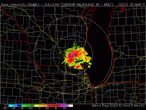
Take a look at the radar from 8pm.
There is still a little light snow/flurries in the area, but not as heavy or widespread as earlier in the day.
I have received quite a few questions today about how it is lake effect snow so far inland. At one time today, there was sunshine in Sheboygan and Ozaukee counties and lake effect snow in Washington, Dodge, and Waukesha counties. This was pretty fascinating to watch. One thing to remember is there is an elevation change as you move into Washington and Waukesha counties. This elevation change was just enough to lift the air and condense the moisture just enough to create lake-effect snow. This is SE Wisconsin’s own version of orographic lifting. We don’t think of ourselves as mountainous, but we still have elevation change. At certain times that can make a big difference in the forecast. Sometimes the Kettle Moraine will get more snow than others, or the temperatures could be a degree colder. That can be just enough of a difference to bring snow and not rain.
As we move through the weekend, the NE winds continue. The cold air is in place so more lake-effect snow showers are likely. Here is the RPM at 7am Saturday morning.
Note the light snow band extending across our area. This will likely continue at least through Saturday night. Here is the snow accumulation for the weekend on the RPM.
Not much snow accumulation, but there could be a few snow squalls that move through making the roads a bit slippery at times. The good thing about this time of year is that light snow has a hard time accumulating on the roads during the day because enough solar radiation makes its way through the clouds quickly melting the snow even when the temperatures are below zero.
Mark


Leave a comment