***Watch WISN 12 News for LIVE coverage of the tornado aftermath in Alabama!***
A devastating once in a generation tornado outbreak hit the deep South on Wednesday. This tornado outbreak will rival the ‘Super Outbreak’ that hit some of the same areas back on April 3-4, 1974.
Meteorologist Mark Baden will be live in the areas hardest hit bringing the pictures and stories of the event to everyone here in southeast Wisconsin. Make sure to watch WISN 12 News at 5, 6, & 10pm for the LIVE reports.
So how did this tornado outbreak occur? In this blog we’ll discuss look at how this tornado outbreak occurred.
Let’s start with this incredible video from the Tuscaloosa News via You Tube showing one of the violent tornadoes from April 27, 2011.
The ‘Super Outbreak’ from April 3-4, 1974 produced 148 tornadoes. In Wednesday’s tornado outbreak there were 179 reported tornadoes. We’ll have to see how many are documented, but this will certainly either top or be very close to what many consider the worst tornado outbreak in U.S. history.
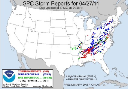
Below are the storm reports from the SPC from Wednesday.
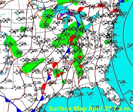
Now why did severe weather form? In order for severe weather to occur, you need three ingredients – moisture, lift, and instability. Those ingredients came together to produce strong and violent tornadoes in the south. The surface map below shows low pressure over Arkansas with a trailing front. This low helped to pump in warm, moist air over the South on Wednesday. Dew points(a measure of moisture) were already in the 60s to 70s at 7 a.m. Wednesday. Also, the surface winds ahead of the low pressure area were south-southeast.
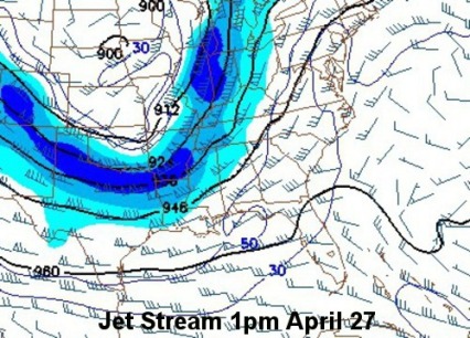
While surface winds over the South were out of a south-southeast direction the jet stream was screaming into the region around 100mph out of the west-southwest. Below is a 300mb map at 1 p.m. Wednesday. The blue area is called a ‘jet streak’ or where the winds were the strongest.
The change in wind speeds and direction with height is called shear. Shear helps thunderstorms to rotate, and in turn produce tornadoes under ideal conditions. Shear is probably the #1 ingredient needed for tornado formation once the thunderstorm has developed. Here is a simulated thunderstorm showing how all of this works. The model below is from the NSSL.
We will continue to update the situation in the South here in the blog and on WISN 12 News. The tornado outbreak on Wednesday was a topic we discussed along with other severe weather aspects at Farmington Elementary in Kewaskum. I had a chance to visit the 3rd grade students at the school Thursday morning, they were a great group and had many fantastic questions. Thank you for inviting me to your school! Below is a picture of the students.
Have a great day and make sure to let us know your thoughts and comments on this very busy month of severe weather across the U.S.! Just drop a note in the comments section of the blog.
Jeremy Nelson


Hi, Jeremy —
Thanks for the explanation of how such storms occur. It seems that they keep “training” across the same area!
Apart from the scientific perspective — the devastation and the losses that have resulted from this tornado outbreak–both in terms of property and people — and how powerless we humans are to prevent such tragedy from occurring just overwhelms me! It used to be “just news” — but now with the capability to see these things as they take place and to see the faces of those dealing with the aftermath–it becomes a personal story in a sense. And there’s always the perspective of “there but for the grace of God are we.” It makes me appreciate more my own family and friends and house and other “stuff” I have — because it could all be gone in a “heartbeat.”
Such storms are truly the kind I hope and pray I never see up close and personal.
Speaking of being appreciative — I think the new set is really cool. You might know, of course, that the computer would freeze up on Mark when you want to show off all the new “bells and whistles.” I wanted to pass this along in yesterday’s blog entry, but it said that the comments section was “turned off.”
One other thing to be sure of — I always appreciate you and Mark and the rest of the WW 12 Team — especially for letting me share so much with you.
Take care. Enjoy “piloting” the new ship tonight while the “chief” is out and about.
Don
Don,
Storms like this show us we really no control…a power much greater than us does! Hard to believe it was daylight when at least half of these storms hit, and there is still this much loss of life. You could have a day or a week to prepare for an EF-4 or EF-5 tornado but the fact is if you are in its path, your fate is a coin flip unless you are in a very hardy structure.
If the comments are ever turned off please let us know. I thought no comments was very odd.
Jeremy
Jeremy —
How do I let you know if the comments are turned off?
I believe that power greater than us is definitely speaking to us! I’m glad to know we’re “on the same page” when it comes to that. I know Mark agrees too! I just wish it wouldn’t take such a strong message to get our attention!
Don
Don,
Just send Mark or myself an email. jdnelson@hearst.com
Jeremy
Hi, Jeremy. I am not complaining about the cold and rainy weather. At least we are being spared from the severe weather. I feel sorry for all the people involved in the tornado outbreak. When will you have the outlook for May?
Sue,
I apologize for the delay in the summer forecast. I’m hoping to get it posted either Friday or Saturday at the latest. Instead of just saying above, below, or average I like to associate some dates with events and also give reasons why certain things should happen. I have the final result done, but how we get there is still being worked on. Thanks for asking.
The next signature storm is due around May 9-12.
Jeremy